
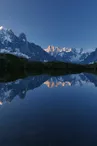
Hike to the Lac Blanc from la Flégère
Chamonix-Mont-Blanc > Chamonix-Mont-Blanc
© OTVCMB_CM


© OTVCMB

Retour Via Ferrata
74400 Chamonix-Mont-Blanc
Departure altitude: 1875 m
Retour Via Ferrata
74400 Chamonix-Mont-Blanc
Arrival altitude: 2353 m
Please note: in order to preserve mountain lakes, swimming is now prohibited at Lac Blanc and Lacs des Chéserys.
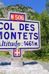
From Chamonix Mont-Blanc, follow signs for Martigny on the road to Les Praz.
Start at Les Praz de Chamonix. Park in the La Flégère gondola parking lot. It's best to take the Flégère gondola, which saves us 800m of uninteresting ascent.
From the top of the gondola station, descend into the Combe de la Chavanne. Near the old stables, on the left, follow the trail that winds up the slope and passes the Chalets et Lac de la Flégère (2,027m).
Take the path below the Tête du Aubuy: it stretches out, skirts a ridge (small lake) and joins the path coming from Argentière. Lac Blanc is reached via the side of a flattening combe. Allow 1h45 one-way.
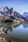
Suggestion: descend to the lovely Chalets et Lacs des Chéserys.
Further information available from the Tourist Office or the Office de Haute-Montagne and in our trail guide.
Please note: trail conditions are subject to change, so check before you set off.
Your contact
Office de Tourisme de Chamonix85 place du triangle de l'amitié
74400 Chamonix-Mont-Blanc
On the itinerary
Positive elevation (ascent): 546 m
Negative elevation (descent): 71 m
Find this route on the Loopi mobile app
Scan the QR code, save it as a favorite, or start the guidance, just enjoy!


Scan the QR code, save it as a favorite, or start the guidance, just enjoy!
This route is provided by: Office de Tourisme de la Vallée de Chamonix-Mont-Blanc
Be cautious and prepared during your outings. Loopi and the author of this sheet cannot be held responsible for any problems that occur on this route.