
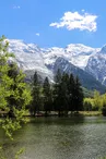
Chamonix > Bel-Lachat hiking trail
Chamonix-Mont-Blanc > Chamonix-Mont-Blanc
© SMBTourisme

© OT chamonix

© OT chamonix

© OT chamonix

© OT chamonix

© OT chamonix

© OT chamonix

© OT chamonix

© OT chamonix

297 Route des Moussoux
74400 Chamonix-Mont-Blanc
Departure altitude: 1089 m
De l'Aiguillette des Houches à Bellachat
74400 Chamonix-Mont-Blanc
Arrival altitude: 2126 m
From the Route des Moussoux, take the Montée des Moëntieux to the Petit
Balcon Sud, cross it and continue on a winding path through undergrowth to the junction with the path from Bois Prin and Les Bossons. Turn right, first into the forest, then through an avalanche corridor to Plan-Lachat (ruins) (1,576 m) 1 h 30. Follow the path into the clearing, leaving the sentier des Gardes on the right, cross a small forest and continue past a large bell tower over the vegetation on a number of switchbacks to Bel-Lachat.
Other routes are possible from Les Bossons, Les Houches or Le Brévent.
Further information available from the Tourist Office or the Office de Haute-Montagne and in our trail guide.
Please note: trail conditions are subject to change, so check before you set off.
Your contact
Office de Tourisme de Chamonix85 place du triangle de l'amitié
74400 Chamonix-Mont-Blanc
On the itinerary

Positive elevation (ascent): 1052 m
Negative elevation (descent): 16 m
Road surfaces
406 m on asphalt or tarred road
4 m on unknown surface in the Open Street Map database
5.47 km on trail and off-road track
Find this route on the Loopi mobile app
Scan the QR code, save it as a favorite, or start the guidance, just enjoy!


Scan the QR code, save it as a favorite, or start the guidance, just enjoy!
This route is provided by: Office de Tourisme de la Vallée de Chamonix-Mont-Blanc
Be cautious and prepared during your outings. Loopi and the author of this sheet cannot be held responsible for any problems that occur on this route.