
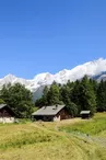
Hiking trail from Les Chavants to Col de la Forclaz via Charousse
Les Houches > Passy
© OT Vallée de Chamonix Mont Blanc

58 Place du Prarion
74310 Les Houches
Departure altitude: 1011 m
1306 Chemin du Col de la Forclaz
74190 Passy
Arrival altitude: 1544 m
On the route of the Tour du Mont-Blanc
At the top of the village, take the road on the right towards the Côte des
Chavants. Go up to the left on the path that leads to the Granges des Chavants
(1 256 m) 0 h 40. On the left, an itinerary goes towards the Col de Voza.
Continue to the right on a path on the side that crosses corridors to go into the forest (Vaudagne water reservoir). In a bend (1 282 m), it joins the forest track coming from Vaudagne which reaches the pass by a rather steep climb.
Routes : It is possible to go down to Vaudagne by using
the path, partly GRP variant, by the Mont-Borrel and the Bouchards. - In the same way, it is interesting to come back by the village of Vieux-Servoz and Servoz by using the GRP variant itinerary by Montcoutant and le Châtelard, on the
descent.
Other itineraries are possible from Vaudagne or Le Prarion.
More information is available at the Tourist Office or the Office de Haute-Montagne and in our trail guide.
Attention : The conditions of the trails are likely to change, think of informing you before leaving.
Your contact
Office de Tourisme de Chamonix85 place du triangle de l'amitié
74400 Chamonix-Mont-Blanc
On the itinerary
Positive elevation (ascent): 534 m
Negative elevation (descent): 0 m
Road surfaces
2.10 km on asphalt or tarred road
320 m on unknown surface in the Open Street Map database
1.57 km on rolling path (compacted sand, gravel, cobblestones)
1.21 km on trail and off-road track
Find this route on the Loopi mobile app
Scan the QR code, save it as a favorite, or start the guidance, just enjoy!


Scan the QR code, save it as a favorite, or start the guidance, just enjoy!
This route is provided by: Office de Tourisme de la Vallée de Chamonix-Mont-Blanc
Be cautious and prepared during your outings. Loopi and the author of this sheet cannot be held responsible for any problems that occur on this route.