
Aiguillette d'Argentière hiking
Chamonix-Mont-Blanc > Chamonix-Mont-Blanc
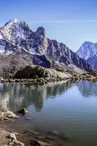
© OTVCMB

© OTVCMB

Sentier du Col
74400 Chamonix-Mont-Blanc
Departure altitude: 1418 m
Tour du Pays du Mont-Blanc
74400 Chamonix-Mont-Blanc
Arrival altitude: 1866 m
The trail starts near the parking of Trélechamp-le-Haut. It passes on the side of a big rock slab, then on the Plan de la Grange. Entering a beautiful forest of larches, it goes up diagonally until 1710m. Turn right and go up in twists and turns until **at the foot of the rocky bar of the Cheserys that you have to follow until the Aiguillette.
More information available at the Tourist Office or the Office de Haute-Montagne and in our trail guide.
Attention : The conditions of the trails are likely to change, think of informing you before leaving.
Your contact
Office de Tourisme de Chamonix85 place du triangle de l'amitié
74400 Chamonix-Mont-Blanc
On the itinerary
Positive elevation (ascent): 488 m
Negative elevation (descent): 33 m
Road surfaces
19 m on asphalt or tarred road
46 m on unknown surface in the Open Street Map database
2.55 km on trail and off-road track
Find this route on the Loopi mobile app
Scan the QR code, save it as a favorite, or start the guidance, just enjoy!


Scan the QR code, save it as a favorite, or start the guidance, just enjoy!
This route is provided by: Office de Tourisme de la Vallée de Chamonix-Mont-Blanc
Be cautious and prepared during your outings. Loopi and the author of this sheet cannot be held responsible for any problems that occur on this route.