
Hike to Lac Blanc from Col des Montets
Chamonix-Mont-Blanc > Chamonix-Mont-Blanc


2906 Route des Montets
74400 Chamonix-Mont-Blanc
Departure altitude: 1468 m
2906 Route des Montets
74400 Chamonix-Mont-Blanc
Arrival altitude: 2348 m
Please note: in order to preserve mountain lakes, swimming is now prohibited at Lac Blanc and Lacs des Chéserys by prefectoral decree.
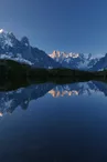
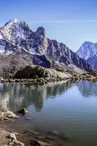
Nestled in the heart of the Aiguilles Rouges Nature Reserve, this often snow-covered lake is the center of a beautiful viewpoint over the Aiguilles de Chamonix, the Drus and the Verte.
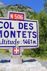
Departure from Col des Montets: Behind the nature reserve chalet, the path winds up a combe for 400m. It reaches the sloping plateau of La Remuaz: below on the left is the Jeunesse et Montagne monument (1943), and on the right the small Lac de la Remuaz. It reaches the Tête aux Vents crossroads. Turn right. The path skirts a ridge. The 5 pretty lakes become visible as you climb, provided you stay on the right-hand path. From the last lake, the path straightens out at an equipped passage over large rounded boulders, leading to a depression overlooking the lake and the refuge.
Further information available from the Tourist Office or the Office de Haute-Montagne and in our trail guide.
Please note: trail conditions are subject to change, so check before you set off.
Your contact
Office de Tourisme de Chamonix85 place du triangle de l'amitié
74400 Chamonix-Mont-Blanc
On the itinerary
Positive elevation (ascent): 872 m
Negative elevation (descent): 0 m
Find this route on the Loopi mobile app
Scan the QR code, save it as a favorite, or start the guidance, just enjoy!


Scan the QR code, save it as a favorite, or start the guidance, just enjoy!
This route is provided by: Office de Tourisme de la Vallée de Chamonix-Mont-Blanc
Be cautious and prepared during your outings. Loopi and the author of this sheet cannot be held responsible for any problems that occur on this route.