
Grand Balcon Nord: Plan de l'Aiguille du Midi-Montenvers
Chamonix-Mont-Blanc > Chamonix-Mont-Blanc


Accès Zone de Décollage des Parapentes
74400 Chamonix-Mont-Blanc
Departure altitude: 2300 m
Chemin du Montenvers
74400 Chamonix-Mont-Blanc
Arrival altitude: 1895 m
From the cable car station, head down towards the Refuge du Plan de l'Aiguille. Do not take the two paths leading down to Chamonix via Plan du Trois or Pré du Rocher. Go right horizontally on the path that crosses the Tapia, the torrent and the lower moraines of the Blaitière and Nantillons glaciers.
At this point, turn left onto the Chamonix trail through the Alpages de Blaitière.
Continue horizontally, crossing the Grépon torrent. Above
Grand-Chalet, pause to admire the impressive panorama of the
Aiguilles de Chamonix: I'M, les Charmoz, Blaitière, le Plan, l'Aiguille du Midi... and Mont-Blanc.
Shortly afterwards, at 2,071 m, there's a fork in the road: to the left, a steep shortcut leads
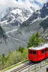
Montenvers, cutting through steep couloirs that are dangerous in snow (for experienced hikers). To the right, take the panoramic path, winding up and crossing over to the lower Signal des Charmoz, then to Signal Forbes (2,198 m). The view changes abruptly: les Drus, la Verte, les Jorasses... On the Mer de Glace side, a long, winding descent leads to Montenvers, the hotel and the train station.
This can be done from Montenvers to Aiguille du Midi.
Check opening dates and times before you go.
Further information available from the Tourist Office or the Office de Haute-Montagne and in our trail guide.
Please note: trail conditions are subject to change, so check before you go.
Your contact
Office de Tourisme de Chamonix85 place du triangle de l'amitié
74400 Chamonix-Mont-Blanc
On the itinerary

Positive elevation (ascent): 47 m
Negative elevation (descent): 447 m
Road surfaces
21 m on unknown surface in the Open Street Map database
5.63 km on trail and off-road track
Find this route on the Loopi mobile app
Scan the QR code, save it as a favorite, or start the guidance, just enjoy!


Scan the QR code, save it as a favorite, or start the guidance, just enjoy!
This route is provided by: Office de Tourisme de la Vallée de Chamonix-Mont-Blanc
Be cautious and prepared during your outings. Loopi and the author of this sheet cannot be held responsible for any problems that occur on this route.