
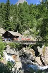
The Tré-les-Eaux Valley
Vallorcine > Vallorcine
© OT Vallée de Chamonix MB

© OT Vallée de Chamonix MB

© OT Vallée de Chamonix MB

© OT Vallée de Chamonix MB

© OT Vallée de Chamonix MB

© OT Vallée de Chamonix MB

Route du Lay
74660 Vallorcine
Departure altitude: 1352 m
Route du Lay
74660 Vallorcine
Arrival altitude: 1936 m
Take the Loriaz path or the forest track to the Hameau des Granges
(1 566 m) : leave these 2 itineraries on the right. Follow the path on the left which
between the houses, goes on the side of the mountain under the Cornes de Loriaz
and climbs a rocky outcrop. A slight descent, with a passage (pitons and chain)
a slight descent, with a passage (pitons and chain), leads to the edge of the torrent in the valley. Continue until the altitude
1 990 m at the entrance of the gorge.
Descent 2 h by the same route or by a steep path (pitons, cable)
that we find on the way back on the right at the Cornes de Loriaz. It follows the water of the Chie des Coins, Tré-les-Eaux, then the Meunière to reach the village of Couteray by Sur-le-Rocher.
Other suggestion:
Possibility to go up to the small lake of the Gouille aux Bouc at about 2,230 m, then to the Cols des Corbeaux and de la Terrasse near the Lac Vert and back down to the refuge of Loriaz. Caution : itinerary without path, materialized by cairns. Possible climbing in the valley of tré les eaux: topo "l'eau noire, les aiguilles rouge 2" Michel Piola
Special difficulties
Quelques passages équipés de chaînes.
Your contact
Office de Tourisme de Chamonix85 place du triangle de l'amitié
74400 Chamonix-Mont-Blanc
On the itinerary
Positive elevation (ascent): 672 m
Negative elevation (descent): 91 m
Road surfaces
169 m on asphalt or tarred road
2.60 km on unknown surface in the Open Street Map database
1.81 km on trail and off-road track
Find this route on the Loopi mobile app
Scan the QR code, save it as a favorite, or start the guidance, just enjoy!


Scan the QR code, save it as a favorite, or start the guidance, just enjoy!
This route is provided by: Office de Tourisme de la Vallée de Chamonix-Mont-Blanc
Be cautious and prepared during your outings. Loopi and the author of this sheet cannot be held responsible for any problems that occur on this route.