
Bérard waterfall trail
Vallorcine > Vallorcine
© ot Vallorcine

© OT Vallorcine

© OT Vallée de Chamonix MB

© Ot Vallorcine

© OT Chx Salomé Abrial

© OT Chx Salomé Abrial

© ot Vallorcine

© OT Vallée de Chamonix MB

44 Route du Montet
74660 Vallorcine
Departure altitude: 1341 m
Sentier de la grotte à Farinet
74660 Vallorcine
Arrival altitude: 1456 m
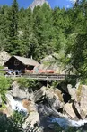
Take the path upstream from the Buet hotel. Cross the typical hamlet of la
Poya, and go up the meadow to the reservoirs: a little above, on the right, you reach the waterfall by a newly built footbridge on the right bank.
Return by the same route.
Possibility to eat at the creamery of the Bérard waterfall.
More information available at the Tourist Office or the High Mountain Office and in our trail guide.
Attention : The conditions of the trails are likely to change, think of informing you before leaving.
Your contact
Office de Tourisme de Chamonix85 place du triangle de l'amitié
74400 Chamonix-Mont-Blanc
On the itinerary

Positive elevation (ascent): 127 m
Negative elevation (descent): 12 m
Road surfaces
133 m on asphalt or tarred road
67 m on unknown surface in the Open Street Map database
771 m on trail and off-road track
Find this route on the Loopi mobile app
Scan the QR code, save it as a favorite, or start the guidance, just enjoy!


Scan the QR code, save it as a favorite, or start the guidance, just enjoy!
This route is provided by: Office de Tourisme de la Vallée de Chamonix-Mont-Blanc
Be cautious and prepared during your outings. Loopi and the author of this sheet cannot be held responsible for any problems that occur on this route.