
Hike to the Lac Cornu from the Planpraz cable car
Chamonix-Mont-Blanc > Chamonix-Mont-Blanc


Grand Balcon Sud
74400 Chamonix-Mont-Blanc
Departure altitude: 2014 m
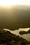
Col Cornu-Lac Cornu
74400 Chamonix-Mont-Blanc
Arrival altitude: 2280 m
From the top of the Planpraz gondola, go up towards the plateau that you cross, pass by the "Altitude 2000" restaurant and the chairlift station and go towards the arrival towers of the chairlifts and ski lifts. Leave on the left the paths going to the Brévent and the Col du Brévent: use the track leading to the Flégère. At about 200m, take the upper left path crossing large grassy slopes. Pass on a promontory, cross a large scree and cross a small gap. Then go up a rather steep slope by a few switchbacks leading to the Col Cornu. Going a little further, we can see below the Lac Cornu. Reach it by descending a path often covered with snow.
Return by the same route.
More information available at the Tourist Office or the High Mountain Office and in our trail guide.
Warning: Trail conditions are subject to change, so please check before you leave.
Your contact
Office de Tourisme de Chamonix85 place du triangle de l'amitié
74400 Chamonix-Mont-Blanc
On the itinerary

Positive elevation (ascent): 385 m
Negative elevation (descent): 112 m
Road surfaces
136 m on unknown surface in the Open Street Map database
215 m on rolling path (compacted sand, gravel, cobblestones)
3.43 km on trail and off-road track
Find this route on the Loopi mobile app
Scan the QR code, save it as a favorite, or start the guidance, just enjoy!


Scan the QR code, save it as a favorite, or start the guidance, just enjoy!
This route is provided by: Office de Tourisme de la Vallée de Chamonix-Mont-Blanc
Be cautious and prepared during your outings. Loopi and the author of this sheet cannot be held responsible for any problems that occur on this route.