
Hike to Le Cerro
Chamonix-Mont-Blanc > Chamonix-Mont-Blanc
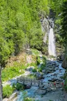
© OT Vallée de Chamonix MB

© OT Vallée de Chamonix MB


© OT Vallée de Chamonix MB

© OT Vallée de Chamonix MB

2028 Route Blanche
74400 Chamonix-Mont-Blanc
Departure altitude: 1059 m
sentier Pélerins d'En Haut vers Cascade du Dard
74400 Chamonix-Mont-Blanc
Arrival altitude: 1366 m
Starting point Route du Téléski aux pèlerins d'en haut. Cross the large footbridge over the Creuse, through the forest to the paved Songenaz road. Go up to the forest path on the left.
Continue up a few hairpin bends in the undergrowth. Reach the glacial moraine and the Chalet du Cerro.
Other routes are possible from Chamonix, the Cascade du Dard, or Les Bossons.
Further information available from the Tourist Office, the Office de Haute-Montagne or in our trail guide.
Please note: trail conditions are subject to change, so check before you set off.
Your contact
Office de Tourisme de Chamonix85 place du triangle de l'amitié
74400 Chamonix-Mont-Blanc
On the itinerary

Positive elevation (ascent): 307 m
Negative elevation (descent): 0 m
Road surfaces
1.41 km on unknown surface in the Open Street Map database
5 m on rolling path (compacted sand, gravel, cobblestones)
852 m on trail and off-road track
Find this route on the Loopi mobile app
Scan the QR code, save it as a favorite, or start the guidance, just enjoy!


Scan the QR code, save it as a favorite, or start the guidance, just enjoy!
This route is provided by: Office de Tourisme de la Vallée de Chamonix-Mont-Blanc
Be cautious and prepared during your outings. Loopi and the author of this sheet cannot be held responsible for any problems that occur on this route.