
La Pierre à Bérard
Vallorcine > Vallorcine
© OT Vallée de Chamonix MB

© Ot Vallorcine

© OT Vallée de Chamonix MB

© OT Vallée de Chamonix MB

© OT Vallée de Chamonix MB

© OT Vallorcine

© OT Vallée de Chamonix MB

© OT Vallée de Chamonix MB

216 Chemin des Mayens
74660 Vallorcine
Departure altitude: 1344 m
2118 Route du Col
74660 Vallorcine
Arrival altitude: 1928 m
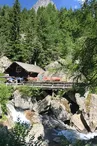
Take the path above the Hôtel du Buet. Walk up the meadow to the Cascade de Bérard chalet. Continue through a beautiful larch forest, and through a deep gorge, reach the first plateau: Fontaine Froide. Further up, cross the torrent at Pont de la Vordette (1,528 m) and climb a rocky escarpment to the second plateau. A succession of flats leads to the foot of the final slope. Cross the Eau de Bérard and, after a few hairpin bends, reach the refuge under a large stone.
Your contact
Office de Tourisme de Chamonix85 place du triangle de l'amitié
74400 Chamonix-Mont-Blanc
On the itinerary

Positive elevation (ascent): 594 m
Negative elevation (descent): 11 m
Road surfaces
87 m on asphalt or tarred road
228 m on unknown surface in the Open Street Map database
6.13 km on trail and off-road track
Find this route on the Loopi mobile app
Scan the QR code, save it as a favorite, or start the guidance, just enjoy!


Scan the QR code, save it as a favorite, or start the guidance, just enjoy!
This route is provided by: Office de Tourisme de la Vallée de Chamonix-Mont-Blanc
Be cautious and prepared during your outings. Loopi and the author of this sheet cannot be held responsible for any problems that occur on this route.