
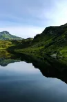
Hike to the Pormenaz Alpine pasture and Lac de Pormenaz
Servoz > Servoz
© OT Vallée de Chamonix-Mont-Blanc

© OT Vallée de Chamonix-Mont-Blanc

© OT Vallée de Chamonix-Mont-Blanc

© OT Vallée de Chamonix-Mont-Blanc

© OT Vallée de Chamonix-Mont-Blanc

© OT Vallée de Chamonix-Mont-Blanc

© OT Vallée de Chamonix-Mont-Blanc

© OT Vallée de Chamonix-Mont-Blanc

© OT Vallée de Chamonix-Mont-Blanc

© OT Vallée de Chamonix-Mont-Blanc

© OT Vallée de Chamonix-Mont-Blanc

5 Route de La Cote
74310 Servoz
Departure altitude: 945 m
Sentier du Vuacheret
74310 Servoz
Arrival altitude: 1945 m
From the pretty fountain, take the road of the Coast until the first bend. A path goes to the right towards the Gorges de la Diosaz and crosses the torrent of Souay. Go up leaving the Tête de la Fontaine and Bajulaz trails on the right. Follow a long steep slope to a pyramid marker to reach the
reach the Chalets des Alpages de Pormenaz (1,925 m) 3 hrs. Cross flat to the
to the Chalets de Chavanne-Neuve (15 minutes from the itinerary) towards the Pointe Noire de Pormenaz : geological curiosity to see, then towards the Lac de Pormenaz.
Possible departure from the Moulins d'en-Haut (859 m) above Servoz,
from where you can join the above itinerary near the Souay torrent.
Other itineraries are possible from Servoz or Passy - Plaine joux.
More information available at the Tourist Office or the High Mountain Office and in our trail guide.
Attention : The conditions of the trails are likely to change, think of informing you before leaving.
Your contact
Office de Tourisme de Chamonix85 place du triangle de l'amitié
74400 Chamonix-Mont-Blanc
On the itinerary

Positive elevation (ascent): 1092 m
Negative elevation (descent): 92 m
Road surfaces
1.25 km on unknown surface in the Open Street Map database
6.52 km on trail and off-road track
Find this route on the Loopi mobile app
Scan the QR code, save it as a favorite, or start the guidance, just enjoy!


Scan the QR code, save it as a favorite, or start the guidance, just enjoy!
This route is provided by: Office de Tourisme de la Vallée de Chamonix-Mont-Blanc
Be cautious and prepared during your outings. Loopi and the author of this sheet cannot be held responsible for any problems that occur on this route.