
Hike to Paradis des Praz
Chamonix-Mont-Blanc > Chamonix-Mont-Blanc

© OT Vallée de Chamonix MB

© OT Vallée de Chamonix MB

© OT Vallée de Chamonix MB

© OT Vallée de Chamonix MB

© OT Vallée de Chamonix MB

© OT Vallée de Chamonix MB

© OT Vallée de Chamonix MB

© OT Vallée de Chamonix MB

© OT Vallée de Chamonix MB

© OT Vallée de Chamonix MB

© OT Vallée de Chamonix MB

Route des Gaudenays
74400 Chamonix-Mont-Blanc
Departure altitude: 1065 m
265 Chemin des Glières
74400 Chamonix-Mont-Blanc
Arrival altitude: 1089 m
From the village, near the chapel, take Les Tines road - N 506 - and then turn
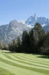
left along the road to the golf course (18 holes). Once over the bridge, turn right along the Promenade du Paradis des Praz, which takes you into the woods where you can wander at leisure, contemplate the streams or rest on the benches.
Other itineraries are available from Chamonix or Les Tines.
More information at the Tourist Office, the High Mountain Office, and in our hiking guide.
Careful: path conditions may change - remember to check the latest information before setting off.
Your contact
Office de Tourisme de Chamonix85 place du triangle de l'amitié
74400 Chamonix-Mont-Blanc
On the itinerary
Positive elevation (ascent): 22 m
Negative elevation (descent): 0 m
Road surfaces
406 m on asphalt or tarred road
734 m on unknown surface in the Open Street Map database
598 m on trail and off-road track
Find this route on the Loopi mobile app
Scan the QR code, save it as a favorite, or start the guidance, just enjoy!


Scan the QR code, save it as a favorite, or start the guidance, just enjoy!
This route is provided by: Office de Tourisme de la Vallée de Chamonix-Mont-Blanc
Be cautious and prepared during your outings. Loopi and the author of this sheet cannot be held responsible for any problems that occur on this route.