
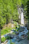
Hike to Le Dard waterfall
Chamonix-Mont-Blanc > Chamonix-Mont-Blanc


Carrefour du Grepon
74400 Chamonix-Mont-Blanc
Departure altitude: 1034 m
La Route Blanche
74400 Chamonix-Mont-Blanc
Arrival altitude: 1240 m
From the Centre ville Grepon car park in Chamonix, on your right take Chemin du Batioret, which runs alongside Route Blanche. Cross the bridge over the mountain stream and head up to Les Molliasses. Continue past the forest track on your left. Turn right up to the road leading to the tunnel. Follow it for about 50 metres, then turn left to take a shortcut over a short distance. Continue upwards through the trees, ignoring the path from les Pelerins to your right.
Others itineraries are available from Les Pélerins or on the road leading to Tunnel du Mont-Blanc.
More information at the Tourist Office, the High Mountain Office, and in our hiking guide.
Careful: Path conditions may change - remember to check the latest information before setting off.
Your contact
Office de Tourisme de Chamonix85 place du triangle de l'amitié
74400 Chamonix-Mont-Blanc
On the itinerary
Positive elevation (ascent): 410 m
Negative elevation (descent): 204 m
Road surfaces
448 m on asphalt or tarred road
271 m on unknown surface in the Open Street Map database
21 m on rolling path (compacted sand, gravel, cobblestones)
2.65 km on trail and off-road track
Find this route on the Loopi mobile app
Scan the QR code, save it as a favorite, or start the guidance, just enjoy!


Scan the QR code, save it as a favorite, or start the guidance, just enjoy!
This route is provided by: Office de Tourisme de la Vallée de Chamonix-Mont-Blanc
Be cautious and prepared during your outings. Loopi and the author of this sheet cannot be held responsible for any problems that occur on this route.