
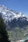
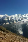
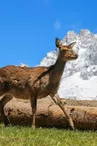
Hike to the Alpage of Chailloux
Les Houches > Les Houches
© Office de Tourisme Vallée de Chamonix Mont-Blanc - MR

© Office de Tourisme Vallée de Chamonix Mont-Blanc - MR

© Office de Tourisme Vallée de Chamonix Mont-Blanc - MR

© Office de Tourisme Vallée de Chamonix Mont-Blanc - MR

© Office de Tourisme Vallée de Chamonix Mont-Blanc - MR

© Office de Tourisme Vallée de Chamonix Mont-Blanc - MR

© OTVCMB_LB

© OTVCMB_LB

474 Route de la Flatière
74310 Les Houches
Departure altitude: 1344 m
Sentier « En Forme » (2h) - Zone de silence
74310 Les Houches
Arrival altitude: 1924 m
Departure from the hamlet of Coupeau, join La Flatière, parking possible on the parking lot of Le Bettey. On foot, follow the direction of Plan de la Cry. Leave on the right the path leading to the Parc Animalier de Merlet and on the left, the one leading to Pierre Blanche: take the path going up in front of you in the forest by many twists and turns. It crosses clearings, corridors and woods where this path meets the one coming from Merlet. In 2 turns, reach the Alpage de Chailloux (1913m) in 2h10.
Suggestions : From the Alpage de Chailloux possibility to continue to the Aiguillette des Houches.
Other itineraries are possible from Les Houches, Chamonix, Coupeau...
More information available at the Tourist Office or at the High Mountain Office and in our trail guide.
Attention : The conditions of the trails are likely to change, think of informing you before leaving.
Your contact
Office de Tourisme de Chamonix85 place du triangle de l'amitié
74400 Chamonix-Mont-Blanc
On the itinerary

Positive elevation (ascent): 580 m
Negative elevation (descent): 0 m
Road surfaces
137 m on asphalt or tarred road
539 m on unknown surface in the Open Street Map database
1.40 km on rolling path (compacted sand, gravel, cobblestones)
1.77 km on trail and off-road track
Find this route on the Loopi mobile app
Scan the QR code, save it as a favorite, or start the guidance, just enjoy!


Scan the QR code, save it as a favorite, or start the guidance, just enjoy!
This route is provided by: Office de Tourisme de la Vallée de Chamonix-Mont-Blanc
Be cautious and prepared during your outings. Loopi and the author of this sheet cannot be held responsible for any problems that occur on this route.